Niwot Master Plan 2025
In 2024 and 2025, Niwot asked a question it had never formally put to itself: if we could improve this place, what would we actually do? The answer runs to thirty-one drawings. This page walks through them — what the plan proposes, who made it, and what stands between the drawings and the ground.
The Niwot Incorporation Committee did not write this plan and is not adopting it. We are publishing it because it is the best existing record of what this community said it wanted when somebody finally asked — drawn by a local firm, commissioned by the LID, and shaped across a year of public meetings.
Nothing in it is a commitment, and none of it is a campaign promise. If Niwot incorporates, this is a starting point — something an elected board could take up, revise, or set aside. A community deciding whether to govern itself ought to be able to see what it has already said about the place it wants.
The Niwot Local Improvement District (LID) Advisory Committee, a nine-member board that advises the Boulder County Commissioners on spending that benefits the Niwot business district.
Prepared byFletemeyer & Lee Associates, the architecture and planning firm on Second Avenue in Niwot. Principals Dave Lee and Chad Fletemeyer led the work.
ProcessThe work ran through 2024 and into 2025, built on community input and a review of Niwot’s earlier planning efforts. The draft was presented at a community meeting at The Wheel House on December 2, 2024, which the Left Hand Valley Courier reported drew roughly sixty people, including County Commissioner Claire Levy.
DeliveredApril 2025. Adopted by the LID Advisory Committee in May 2025 and posted by Boulder County that June. The plan looks out twenty to thirty years.
How to Read a Master Plan
A master plan is not a blueprint, and the difference matters more than it sounds. Planners work with three broadly different kinds of document. A regulatory plan carries legal force: it governs what may be built where, and a proposal that conflicts with it can be denied. A capital plan carries money and a schedule. An illustrative master plan carries neither. It is a picture of what a place could become, drawn well enough that people can argue with it.
This is an illustrative plan. It has no legal force at all.
That is also why the drawings are so specific. When Fletemeyer & Lee drew a sundial, a bocce court, and a particular arrangement of benches onto the Cottonwood corner, they were not predicting that Niwot will one day build a sundial. They were doing what designers do — turning an unarguable abstraction into something concrete enough to react to. Nobody objects to “more gathering space.” Plenty of people have an opinion about a bocce court. The specificity is a tool for getting a community to say what it actually wants, and across a year of meetings it did that work.
So read every drawing here as a question rather than an answer. Not this is what goes there, but something like this could go there — does that appeal to you? The horizon is twenty to thirty years. Nobody expects a plan like this to be executed as a package, in order, or in full. It succeeds if, a decade on, a few of its ideas have been built by whoever had the money and the opening at the time, and the rest still reads as a direction worth going.
Niwot does have a regulatory plan. Land use here is governed by the Boulder County Comprehensive Plan through the Niwot Community Service Area, a designation adopted in 1988 and carried forward through every revision since. That document has force over what Niwot can be. Niwot did not write it and cannot amend it. The plan on this page is the one Niwot wrote for itself — and it is the one with no force at all.
Nothing in the plan is funded, and nothing has been approved for construction. Several of its best ideas also sit on land the community does not own — the Cottonwood Park HOA corner parcel, the Cottonwood Square Shopping Center, the Grange Hall, and the Excel Electric property are all privately held. Those proposals would depend entirely on owners who chose to take part.
The Ten Improvement Areas
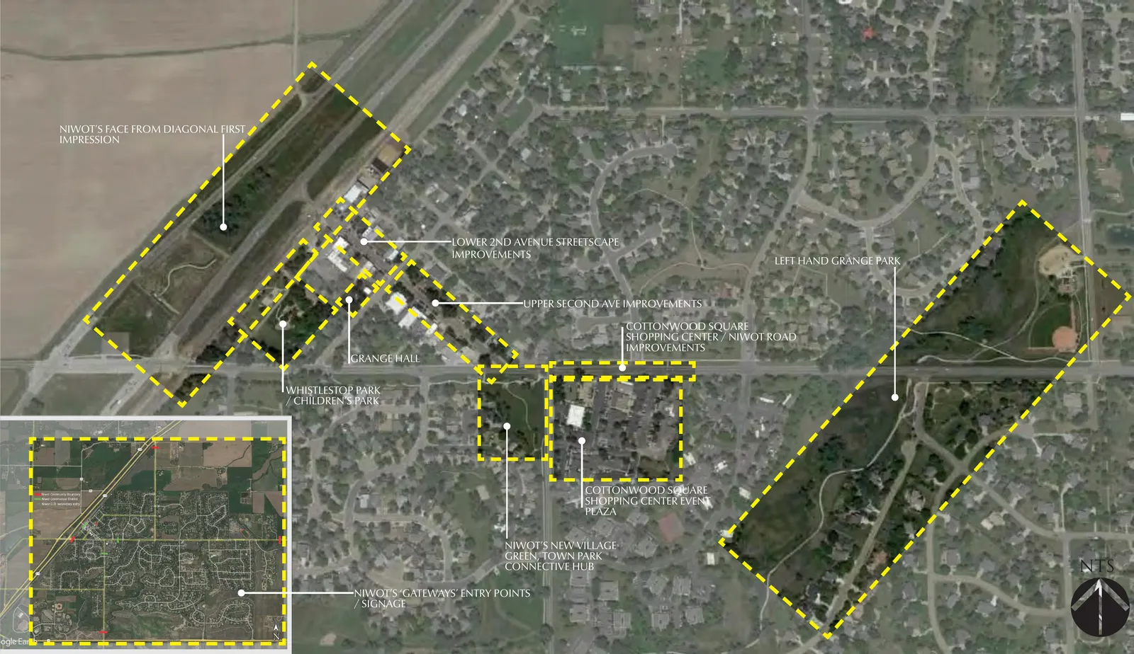
The plan identifies ten improvement areas across Niwot, from the Diagonal Highway frontage to the far edge of Left Hand Valley Grange Park. They are grouped below into eight parts.
The Organizing Idea
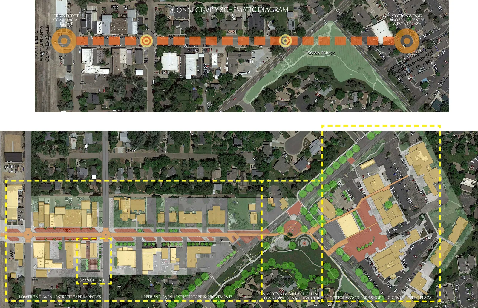
Underneath the ten areas is a single argument. Niwot has two commercial districts — Second Avenue and Cottonwood Square — separated by a road that is difficult to cross on foot. The plan treats them not as two places but as one downtown that has never been stitched together, and much of what it proposes is in service of that stitching: the crossings, the village green in the middle, the paths, the shared signage.
Niwot's First Impression
The gateway from the Diagonal Highway
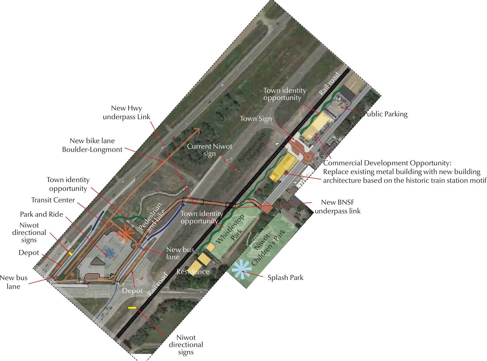
The area along the Diagonal Highway is Niwot's front door. Today it is dominated by a parking lot, an aging bank drive-up, and open fields with no visual cue that a historic community lies just beyond the railroad tracks. The plan treats this as the single biggest opportunity to change how Niwot reads to someone passing at 65 miles an hour.
- New town sign and identity gateway visible from the Diagonal Highway
- Transit center with park-and-ride and new bus lanes
- New highway underpass link for pedestrians and cyclists
- Boulder–Longmont bike lane connection
- Splash park and children's play area at Whistlestop Park
- Commercial development on the Excel Electric property, designed in the historic train station motif
- Niwot directional signage at key entry points
Second Avenue Streetscape
The heart of Niwot's commercial district
Lower Second Avenue's charm comes from the scale of its historic facades, street trees, brick pavers, lamp posts, and flower baskets. But the street is still dominated by wide asphalt lanes designed for automobiles, and in places the sidewalk narrows sharply with a steep drop-off to the road. The objective is not a particular paving material — it is a street that works on foot for its full length, so that moving from Murray Street toward Cottonwood Square feels like one continuous place rather than three disconnected ones.
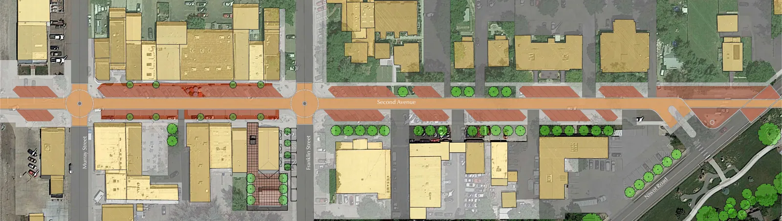
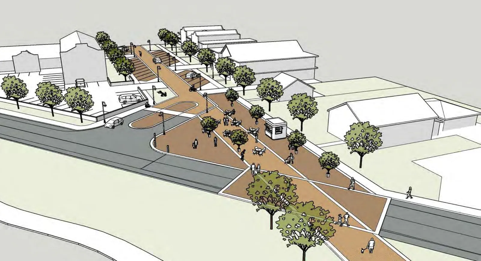
- Narrow the drive lanes and change the paving surface to create a pedestrian-first character
- Extend the brick paver streetscape from lower to upper Second Avenue
- Add street trees, benches, and landscaping along the full corridor
- Redesign the awkward Second Avenue and Niwot Road intersection for safety and appearance
- Create a continuous, safe pedestrian route from Murray Street to Niwot Road
Historic Grange Hall
Outdoor space for a community landmark
The Left Hand Grange Hall is one of Niwot's most recognizable buildings and is used for community events of every kind. It sits on a large parcel but makes almost no use of its outdoor space, and a metal storage building at the back occupies ground that could serve the community better. The Grange Hall is owned by the Grange, not by the public.
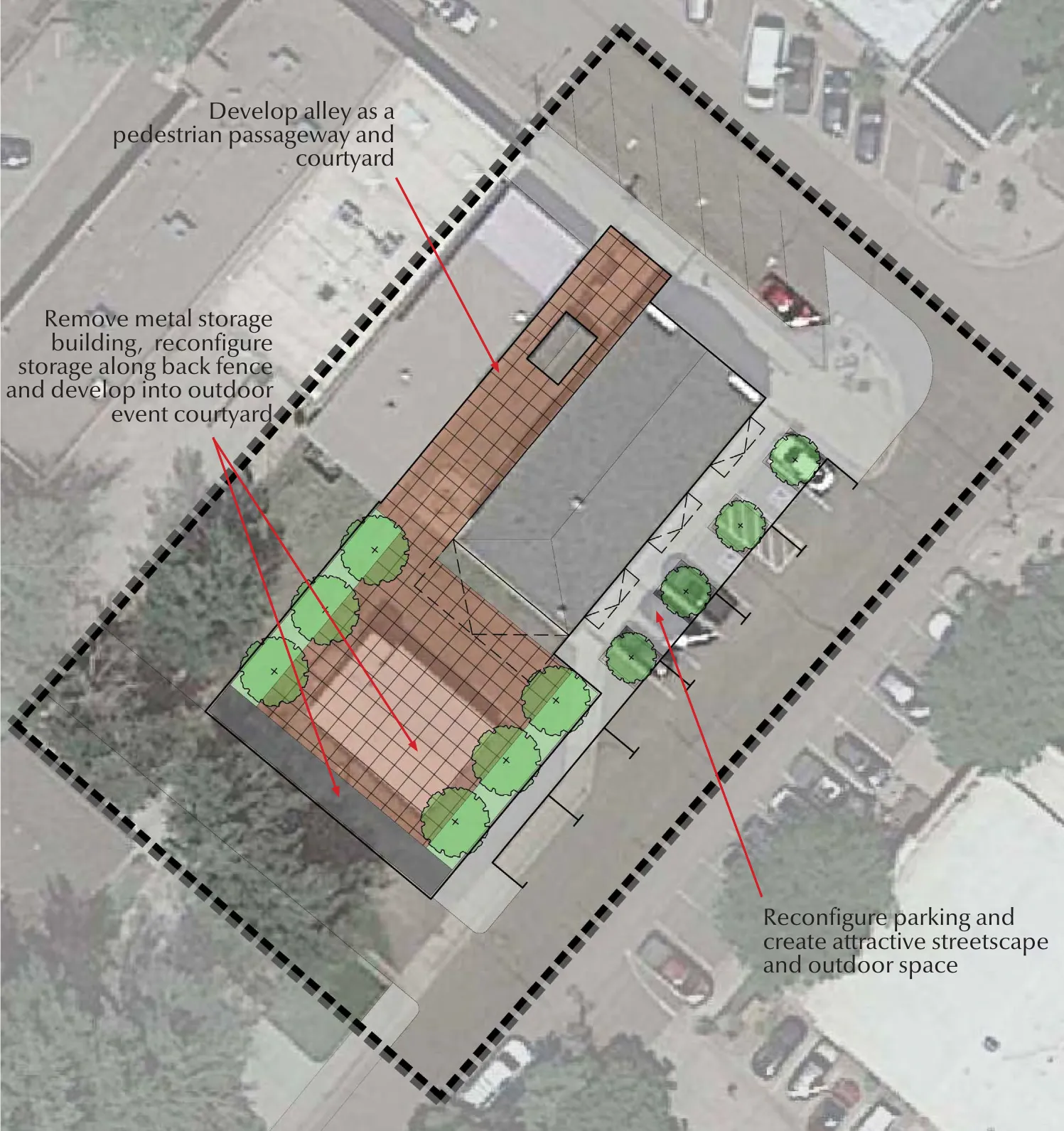
- Develop the alley as a pedestrian passageway and courtyard
- Remove the metal storage building and reconfigure storage along the back fence
- Create an outdoor event courtyard with lighting, landscaping, and flexible seating
- Widen the pedestrian space and add landscaping along Franklin Street
- Reconfigure parking to create streetscape and outdoor gathering space
New Village Green and Town Park
The connective hub between Second Avenue and Cottonwood Square
Crossing Niwot Road is the central obstacle keeping Niwot's two commercial districts from working as one walkable place. The plan identifies the Cottonwood Park HOA corner parcel as the opening for a pedestrian corridor linking Second Avenue to the Cottonwood Square Shopping Center, with a small green at its center. This parcel is privately held by the homeowners association.
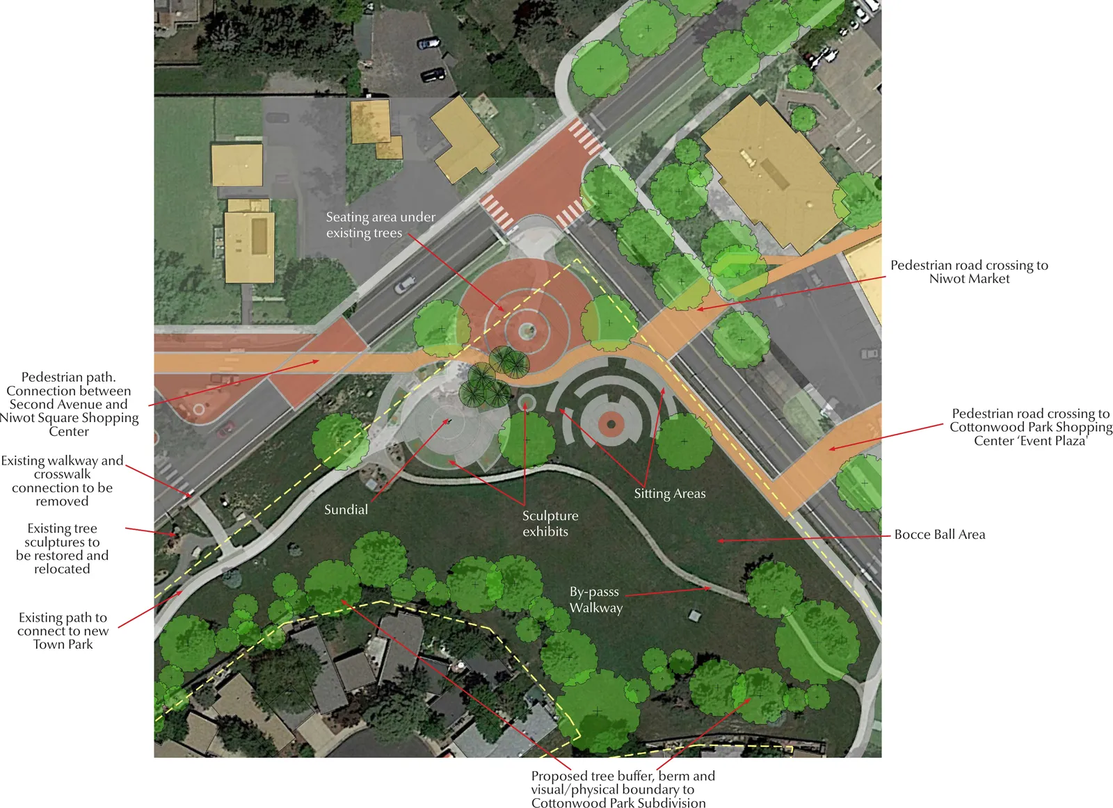
- Pedestrian path connecting Second Avenue to the Cottonwood Square Shopping Center
- New pedestrian road crossings to Niwot Market and Cottonwood Square
- Central sundial feature with sculpture exhibits
- Bocce ball area, sitting areas, and seating under the existing trees
- Bypass walkway for through-traffic pedestrians
- Tree buffer and berm as a visual boundary to the Cottonwood Park subdivision
- Restoration and relocation of the existing tree sculptures
Cottonwood Square Shopping Center
Event plaza and pedestrian connections
The parking area at the Niwot Market west entry could serve as a special events plaza, closed to traffic for community gatherings. The center's drive lanes are wider than they need to be and could be narrowed to make room for wider sidewalks, outdoor seating, and dining. The internal walkways that create the center's more intimate spaces would become part of a real pedestrian network. Cottonwood Square is privately owned.
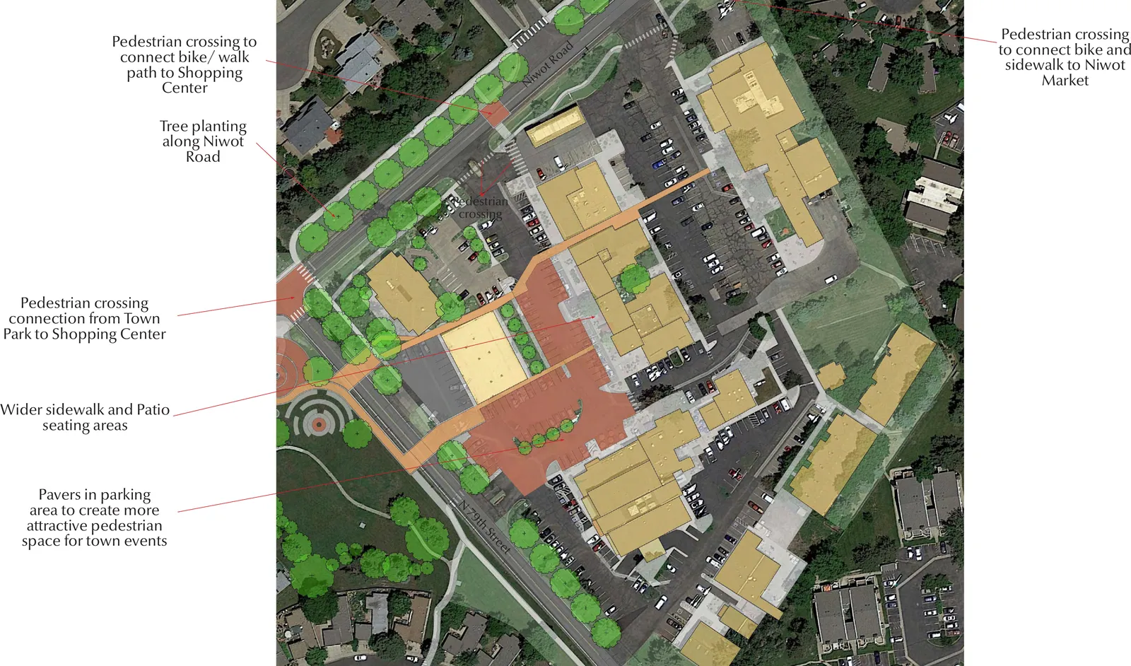
- Event plaza at the west parking area, convertible for pedestrian events
- Pedestrian crossings connecting bike and walking paths to the shopping center and Niwot Market
- Tree planting along Niwot Road for a boulevard character
- Wider sidewalks and patio seating areas throughout the center
- Pavers in the parking area to create usable pedestrian space for events
- Pedestrian crossing from the new town park to the shopping center
- Better signage and visual connections to Second Avenue
Niwot Road Connections
Safe crossings and a tree-lined corridor
Boulder County's planned improvements along Niwot Road are an opening the plan asks the community to use. Today the crosswalks lack obvious signage and visual cues for drivers, and sidewalks end abruptly at curb cuts. The plan argues Niwot Road should become a connector between the commercial areas rather than the barrier between them.
- More obvious crosswalk signage with solar-powered pedestrian beacons
- Continuous sidewalks with safe transitions across curb cuts and entries
- Redesigned north entry to Cottonwood Square to resolve grading and drainage problems
- Tree-lined boulevard treatment along Niwot Road
Left Hand Valley Grange Park
A regional park for all ages
Left Hand Valley Grange Park is Niwot's largest green space — a natural area of trails, wetlands, and mature trees running from the Diagonal Highway to the LoBo Trail. The plan imagines it as a regional park with a wider range of recreation while keeping its natural character intact.
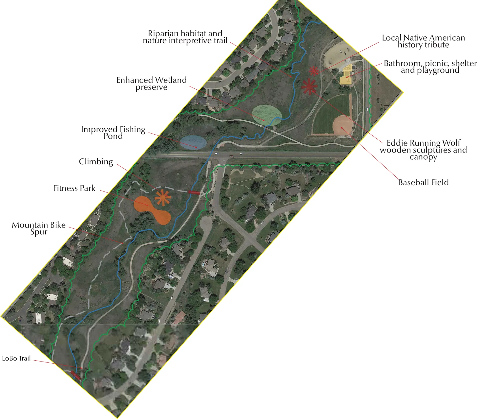
- Riparian habitat and nature interpretive trail along the creek
- Enhanced wetland preserve
- Improved fishing pond
- Climbing wall and fitness park
- Mountain bike spur trail
- Local Native American history tribute with Eddie Running Wolf wooden sculptures and a canopy
- Bathroom, picnic shelter, and playground improvements
- Baseball field enhancements
- LoBo Trail connection
Gateways and Signage
Eight entry points
The plan treats signage as its own improvement area rather than a finishing touch. It identifies eight locations — four marking the community as a whole, four marking the commercial district — and proposes a consistent identity across all of them, so that arriving in Niwot registers as arriving somewhere.
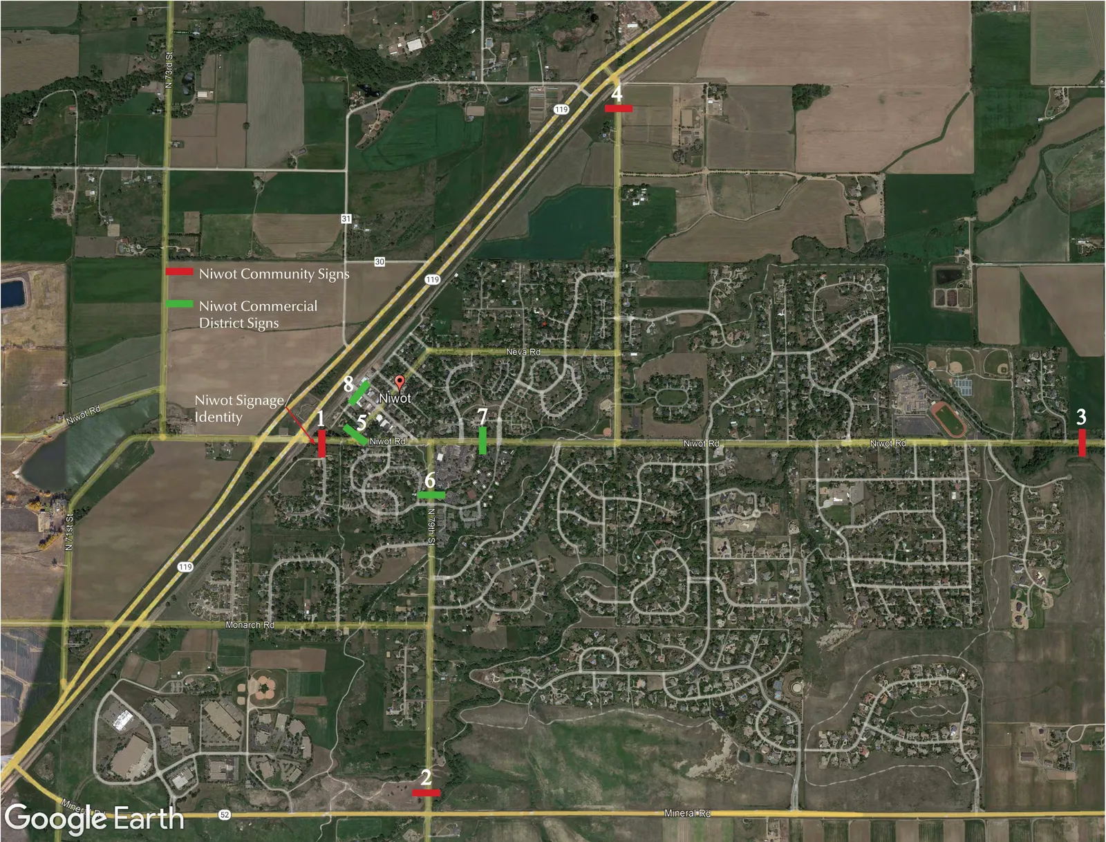
- Four community identity signs: Niwot Road, 79th Street, Niwot Road, and 83rd Street
- Four commercial district signs: Franklin Street, 79th Street, Niwot Road, and Second Avenue
- A consistent signage and identity system across all eight locations
Why a Plan Is Not Enough
A year of meetings produced a serious document. What it did not produce is anyone with the authority to act on it.
The LID Advisory Committee that commissioned the plan is an advisory body. It recommends; the Boulder County Commissioners decide. As an unincorporated community, Niwot has no government of its own — no body that can adopt a streetscape standard, apply for infrastructure grants as the applicant, negotiate with a property owner on the community’s behalf, issue debt against a capital project, or set the land-use rules that would shape any of this.
Incorporation would not build the village green, and no one should claim it would. What it would change is who decides. It creates an elected board, accountable to the people who live here, with the authority to take a plan like this one up as a starting point — to fund parts of it, revise it, or set it aside entirely. Today there is no one to make that call. That is the gap, and it is what a vote in November actually addresses.
The full plan. Thirty-one boards, drawn at 36×24 inches for presentation and exported as a single PDF. It also includes existing-conditions photography and reference images this page does not reproduce — many of those reference photographs show other towns, included as examples of a treatment rather than depictions of Niwot.
Boulder County hosts the plan of record on its Niwot Local Improvement District page. This page is a guide to that document prepared by the Niwot Incorporation Committee; the plan itself is the work of the Niwot LID Advisory Committee and Fletemeyer & Lee Associates, and nothing here should be read as speaking for either of them.